© www.white-coppice.co.uk 2022

Anglezarke Reservoir
Set in miniature Lake District and beautiful it is too
Anglezarke Reservoir....
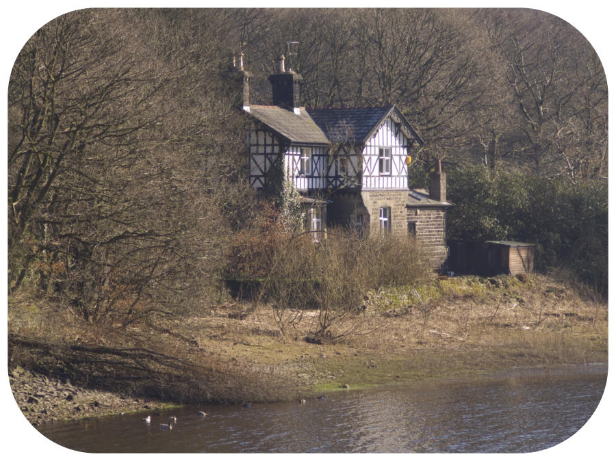
...is the longest in the eight reservoirs with a surface area of 176.9 acres and a perimeter of 4.3 miles. There are three embankments, namely Charnock - 850yds Knowsley - 240yds Heapey - 93yds For three quarters of a mile from the Heapey Embankment the reservoir is shallow, probably no more than 12 to 15ft deep. Beyond that, it does get deeper as times of draught has proven,the Heapey end dry and waterless whilst the Heath Charnock end has plenty. Before it was flooded in the 1850’s it was a lovely tranquil flat bottomed valley with trees intermittently spaced and was popular with local people. it was called The Lees. On the Chorley side there are at least 3 footbridges below the waterline, along with the old lane that was replaced by the Heapey Embankment. At the Lister Mill Quarry end, below the surface are the ruins of Lister Mill, and several farms and their buildings At the northern end stand Heapey Waterman’s Cottage, a fine house built in the Tudor style to house the Waterman. Anglezarke Reservoir had a path circumnavigating the reservoir with the stone wall boundary and much of this path can still be seen today. It is the fourth reservoir in the chain and fed from Rake Reservoir at Abbey Village by a 3.5 man made watercourse called the Goit (sometimes called The Goyt). Footpaths For the most part, it is possible to walk around the reservoir keeping quite close to the shoreline. It is probably better to start the walk from the Knowsley Embankment (SD6200 1555) as parking is plentiful there. Below The Surface When the water levels are low and in 2013 they were low, very low. Yarrow was at least 40 ft lower than normal, and Anglezarke by a similar amount. With Anglezarke being a much larger reservoir in terms of area, more was revealed. The Heapey end, which is quite shallow, used to be called The Lees and was a local beauty spot. The bases of tree trunks are still to be found, along with hedgerow bushes, probably hawthorn or blackthorn. An old release valve is also revealed alongside Heapey embankment, It was this valve that has caused much leaking for many years. Also revealed near the High Bullough inlet bay was the foundation of a dry stone wall and fencing. Across from there on the Healey Nab side, is the pipeline that took water from High Bullough reservoir to the holding reservoir near Chorley (top of Crosse Hall Lane). What we now call High Bullough reservoir was originally built by Chorley Corporation and piped to the reservoir top of Crosse Hall Lane were all the filter beds etc were sited. When Liverpool subsequently built Angelzarke Chorley Reservoir name changed to High Bullough to stop confusion. The pipe from High Bullough went under Angelzarke - and can still be found at the base of High Bullough north dam. The water was then taken same line to the holding reservoir. If you notice the bridge for Crosse Hall Lane across M61 is about 10 feet deep - to contain the pipe down into the holding area. The pipeline is no longer used and the holding reservoir empty. Further south by the Charnock embankment a spit of land was revealed, man made, and I can only hazard a guess that it was built to stop underwater currants from damaging the Charnock embankment, but I could be well off the mark with that idea. My most interesting “find” in Anglezarke is Lister Mill, the foundations of which can clearly be seen, along with a very large stone that is split in two now but originally carried a spindle of some sort through its centre.