© www.white-coppice.co.uk 2022
The Chorley - Blackburn Railway
Details of the line between Chorley and Cherry Tree

Overview
.
Squabbles
The LNWR saw it as a way into the stronghold of the Lancashire & Yorkshire Railway (LYR) if they helped the LUR.
However, the LYR saw it as a threat to its East Lancs stronghold and put forward plans for its own line between
Chorley and Blackburn. A long struggle followed whilst evidence by all interested parties was put before a House of
Commons Committee. It was eventually decided that the LYR plan should be built jointly by the LUR and the LYR; that
of a railway branching off the Bolton - Preston Line at Chorley and joining the Preston - Blackburn line just west of
Cherry Tree. On 6/12/1866 work began on the Chorley - Cherry Tree line.
Building the line
Work began on 6th December 1866, but it was delayed by further negotiations. The total length of the line from
Cherry Tree junction to Chorley was 7 miles 60 chains (a chain being 22yds or 66ft). It cost over £500,000 which
was very expensive in Victorian times for a railway of only 7.25 miles . After inspections it opened on 1/12/1869
It was over budget, due mainly to difficulties crossing the River Roddlesworth and its valley (which is north of
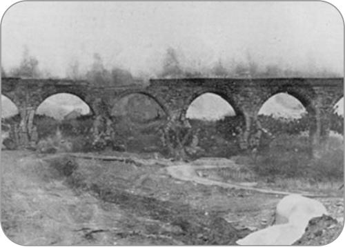
Abbey Village) and several other smaller streams near by. There was also the large 9 arch viaduct crossing the
Leeds - Liverpool Canal (Lancaster Canal as it was known then). One other large expensive construction was the
Three Arch Bridge (over the A674) and embankment to it that connected the line to the Preston - Blackburn Line
near Cherry Tree.
The owners, however, saw potential for the line. Apart from the need to move coal, there were several industries
along the line that would want sidings running to them. Sidings, sometimes almost small branch lines, were built
into them, as was the case at Heapey Bleach Works and Abbey Village Mill.
Although it was built for goods transportation, between the existing stations at Chorley and Cherry Tree, four
stations were erected at Heapey, Brinscall, Withnell and Feniscowles at a cost of approximately £6000 in total. All
these stations had goods/freight facilities. All except Brinscall, were of the same design. Brinscall, unlike the other
stations was a one storey building.
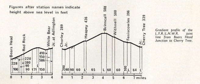
The line
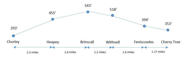
Chorley to Heapey - 2.3 miles
Although there were through services from Blackburn to Wigan there was also a
local Chorley - Blackburn service. These trains left Chorley from a bay platform to
the left of the present day Preston bound platform. Leaving the bay, trains would
pass to the left of a watering tower, cross over Brunswick Street bridge and the
Preston Bolton lines at Chorley No4 signal box, then swing onto the Blackburn line.
The height here is 294 feet. After passing an engine shed the train went under
Stump Lane Bridge 40 yards to the east of the Preston Bolton line. From here it was
more or less uphill all the way to Brinscall. The Blackburn line crossed Harpers Lane
over a bridge (320ft) and was already 40 feet higher than the Preston line. Half a mile further on from Harpers Lane the
line crossed a 9 arch stone viaduct that spanned the valley and the Leeds - Liverpool canal before reaching the Chorley
Blackburn main road (A674) at a height of approx 380 feet. The viaduct was 300 feet long, 48 ft high and each arch was
33 feet wide. It stood for 100 yrs, before being blown up in 1968 to make way for the M61 motorway. There was a short
embankment until the line entered a cutting and went under a bridge below the A674. From here the line continued
turning to the right as it left the cutting and crossed another embankment. Now heading due east it entered another
cutting 50 yards north of Phillipson’s Farm going under the bridge on Tithebarn Lane, Heapey. The line began to turn to
the left and in 400 yards after passing the branch siding on the right leading to Heapey Bleach and Dye Works, it
entered Heapey Station (455 ft)


(Abbey
Village)


To
Preston


Abbey Village
Mill
To
Preston
To
Bolton
Heapey to Brinscall (1.6 miles)
Leaving Heapey Station the line immediately went below Coppice Lane and started to turn northeast and as it left the
cutting a branch line went off to the left and entered ROF Heapey. Between that and the mainline were several siding
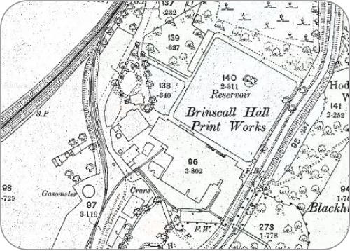
for ROF use. Just under a mile after leaving Heapey there was a branch off to the right (from the north) into Brinscall
Hall Printworks. Today the gateposts guarding the entrance to the sidings still stand, though the gate is long gone.
After passing these gateposts, the line leaves the cutting and starts to cross an embankment that lead to Brinscall
Station. The trackbed here has been built on and several dwellings occupy the original route. Nearing Brinscall
Station the line crossed a bridge over School Lane and then entered the station. This was the highest point on the ine
at 543 feet. Much of the climb from Chorley being at 1 in 60.
Brinscall to Withnell (1.2 miles)
It was 1 in 60 up to Brinscal and it was 1 in 60 down to Cherry Tree. Next was Withnell Station (518 feet), Withnell
should really have been named Abbey Village as that is where it was (and still is today). In the 1.2 miles between
the stations there is quite a lot of detail. Only a quarter of a mile after leaving Brinscall a line branched off to the right
and went to Withnell Mill. Also from this a further line turned 90 degrees and crossed above Railway Road, Withnell
and headed to Brinscall Quarry. Remnants of the bridge supports can still be found on the hillside on the eastern
side of the road. Passing this offshoot the only tunnel on the line is reached half a mile after leaving Brinscall,
Withnell to Feniscowles (1.6 miles)
Leaving Withnell Station the line is now in open countryside and descending quickly in a NNE direction. This section was a major problem for the builders. Several
streams and rivers in deep valleys had to be crossed and this caused delays. There was a small viaduct crossing the R Roddlesworth but like the viaduct at
Chorley, this too, was demolished after the line closed. Half a mile after leaving Withnell Station a siding ran off to the left and entered Withnell Brickworks.From
there, and after encountering embankments and cuttings the line entered Fenicowles Station (394 feet) which is just off Livesey Branch Road. This station has
been demolished and a property built on the track bed. The bridge crossing Livesey Branch has also been demolished.
Feniscowles to Cherry Tree (1.17 miles)
This section also had no industrial sidings. Firstly it crossed the Leeds Liverpool Canal then the A674 road by a tall three arched bridge which is still there today.
After crossing Three Arch Bridge the line swings to the right across a tall embankment and joins the Preston Blackburn line three quarters of a mile after leaving
Feniscowles Station. Cherry Tree Station (353 feet) is soon reached. The section between Feniscowles Station and the canal has all been built on and the bridge
crossing the canal has gone too, though it is possible to see the northern support wall by the canal, complete with drainpipe.


Closing the line
The Cherry Tree and Chorley Line as it was labelled on the first edition 1:2500 maps died slowly. On 4th January 1960 the
line was closed to passengers. Goods (freight) continued to use it though - passing through the silent and ghostly stations
for 6 years though with less frequency each year. Finally on 3rd January 1966, the line closed to through traffic. A small
section remained between Cherry Tree and Feniscowles until1968 and at the Chorley end a section remained as a long
siding till 1982.
Click links on the
map below to go
to that page
Click any photo to enlarge it

Click to enlarge
Without the help of the following people I would have not been able to create these pages. So I offer my sincere thanks to:-
Mr RM Casserley, Lindsey Blackstock (CBC), Adrian Bradshaw, FW Shuttleworth, LCC, Countryside Books, John and Tom Morris, Boyd Harris, David Clayton and
Carnegie Books, Steve Williams, A Radnedge, M Radnedge, Martin Botts, Blandford 1969 (flickr), Tony Gillett, Brian Hilton, AG Ellis and Sneaky from
28dayslater.co.uk
In 1863 a Railway company callied the Lancashire Union Railway was formed to
meet the needs of Colliery owners in the Wigan area . They wanted to reduce the
price of coal in the East Lancashire towns of Blackburn, Accrington and beyond.
Building a line with a more direct route would lower coal prices for mill owners and
households alike. It was thought that the line would reduce the price of coal by one
shilling a ton, saving the mill owners of Blackburn £20,000 a year. The LUR had the
strong support of another railway company - The LNWR
where the line ran below Bury Lane, Withnell. It isn’t a long tunnel by railway standards being only 106 feet long. A quarter of a mile further on and a spur ran off
to the right to Abbey Village Mill. After 1 mile the line passed below an impressive tall three arched bridge carrying a farm road across the railway, before
reaching Withnell (Abbey Village) Station. The section from Brinscall to Withnell is now a nature reserve and the whole length can be walked. The whole section
from the tunnel to Withnell Station is in a cutting.
Thanks …